
The closest waterfalls near Chennai lie in Andhra Pradesh, roughly 80 to 95 km from the city. Tada, Kailasakona and Nagalapuram suit day trips, while Talakona sits near 190 km.
Many lists stretch “near Chennai” to 500 km or more. This guide stays realistic, sorts falls by distance and flags where sources disagree, so you can plan with confidence.
Key Takeaways
- No notable natural waterfall lies within 50 km of Chennai.
- Three falls sit within roughly 100 km: Tada, Kailasakona and Nagalapuram.
- Talakona is the main option around 190 km.
- Monsoon and post-monsoon months give the strongest flow.
- Tada and Nagalapuram involve rough treks, while Kailasakona is the easiest.
- Distances, fees and timings vary by source, so verify before you go.
Waterfalls Near Chennai at a Glance
The table below compares the falls covered in detail. Distances come from several sources and differ by route, so treat them as approximate.
| Waterfall | Location | Distance from Chennai | Effort | Best months (as reported) |
| Tada (Ubbalamadugu) | Tirupati district, Andhra Pradesh | About 80 to 94 km | Moderate to hard trek | July to December |
| Kailasakona | Narayanavanam, Tirupati district | About 92 km | Easy, short walk | Not stated, reportedly perennial |
| Nagalapuram | Chittoor district, Andhra Pradesh | About 85 to 90 km | Moderate trek | June to December |
| Talakona | Andhra Pradesh | About 192 km | Varies | October to January |
Are There Any Waterfalls Within 50 km of Chennai?
No well-documented natural waterfall sits within 50 km of Chennai. The city lies on a flat coastal plain, and waterfalls need hills and forested streams.
Searches for “waterfalls near chennai within 50 kms” still lead to lists with far-off falls. None of the pages reviewed here named a natural fall in that band.
The practical answer is simple. For a day trip, aim for the Andhra Pradesh border region, where the first hills and forest streams begin.
Falls Near Chennai Within 100 km
Three waterfalls fall inside this range. All sit across the state border, near the foothills of the Eastern Ghats in the Tirupati and Chittoor region.
Distances vary because sources measure from different starting points. Tada, for example, appears as about 80 km on Wikipedia and up to 94 km on travel sites.
Tada Falls (Ubbalamadugu Falls)
Also known as Ubbalamadugu, Tada Falls sits in a dense forest called Siddulaiah Kona. It lies in Tirupati district, close to the Sricity area, per Wikipedia.
Wikipedia gives the height as 100 metres and describes the water as clear. The falls also hold religious meaning, and visitors often come during Maha Shivaratri.
This visit involves a real trek. Wikipedia describes about 10 km in total over rough, rocky ground, though novices can follow a 3 km one-way trail beside a stream.
More experienced trekkers can climb boulders to reach the base of the falls. Beginners should stop at the stream section, since rocks get slippery and footing is uneven.
Reported timings conflict. One source lists 6 am to 6 pm, while another section of the same page says 8 am to 5 pm. Plan to arrive by morning.
Fees conflict too. NativePlanet lists entry as free, while Trawell mentions a forest check post fee of ₹50 per vehicle and ₹50 for a camera. Carry small cash.
NativePlanet says swimming in the base pool is permitted, but it advises caution when flow is high. It also notes the site may close during heavy rain or maintenance.
Best months are July to December, according to NativePlanet, while TravelTriangle suggests October to January. Summer is a poor choice because water levels can drop.
Kailasakona Falls
Kailasakona Falls sits in Narayanavanam mandal, Tirupati district, near a temple dedicated to Shiva and Parvati. It lies on the Uthukottai to Puttur to Tirupati road.
Wikipedia says the main fall is about 40 feet high, with two smaller falls of roughly 4 to 6 feet nearby. It is much shorter than Tada.
Access is the big advantage. Parking holds more than ten cars, and a 3 to 5 minute walk on well-laid steps leads to the main fall.
The path is lit at night, according to Wikipedia. Even so, plan a daylight visit, since forest areas and wet steps carry risks after dark.
The two smaller falls have no paved road, so reaching them takes more effort. Wikipedia gives no entry fee or best season for Kailasakona.
FabHotels describes the falls as perennial and lists them at 92 km. Because that claim comes from one source, expect lower flow in dry months.
Kailasakona suits families, older visitors and anyone who wants a short, easy outing. It pairs well with the temple next to the falls.
Nagalapuram Falls
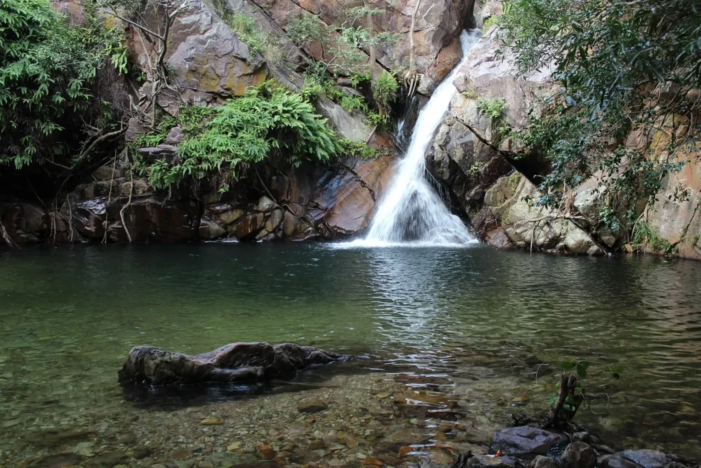
Nagalapuram Falls lies in Chittoor district, about 85 km from Chennai according to a TTD-linked page. Seekatour’s road-trip guide puts the town at about 90 km.
That page says the first waterfall is about a 20-minute walk from the parking area. Reaching the last spot means about 6 km of walking.
Safety history matters here. The page says the falls closed in 2018 for insufficient security, then reopened with forest officials posted and a safety rope at the bathing area.
It also says only one of the three falls was open at the time, with others to follow gradually. Check current status before you travel.
Reported timings are 8 am to 3 pm, with ₹50 entry and ₹50 bike parking. That page dates from January 2025 and says it is not the official TTD site.
Public transport is limited, so a two-wheeler or car works best. The page suggests leaving around 6 am and carrying food, water and a towel, since nothing sells on site.
Best months are June to September, according to that page’s FAQ, though its other text says August to December. Avoid March to June, when heat and humidity peak.
Falls Near Chennai Within 100 km: Which One Should You Choose?
Your choice depends on effort, time and company. The table below matches each fall to a traveler type, so you can decide quickly.
| If you want | Choose | Why |
| The easiest outing | Kailasakona | Short walk, parking, steps |
| The tallest fall | Tada | Wikipedia lists 100 metres |
| A forest walk with limited crowds | Nagalapuram | Longer walk, fewer facilities |
| Travel with young children or older relatives | Kailasakona | Minimal trekking |
| A full day with some adventure | Tada | Longer trail and boulders |
Waterfalls 100 to 250 km from Chennai
Several sources list Talakona at about 192 to 193 km, in Andhra Pradesh. FabHotels calls it the highest waterfall in Andhra Pradesh at 270 feet.
That claim conflicts with Wikipedia’s 100 metres for Tada, which is taller. The conflict shows why you should avoid “highest” labels without a clear source.
TravelTriangle suggests October to January for Talakona. A drive of this length works best as a long day trip or an overnight stay.
Kaigal Falls appears at roughly 223 to 234 km. FabHotels says the flow roughly doubles in monsoon, so visits during or after the rains make the most sense.
Treat these as planning notes, not tested routes. Confirm road conditions, entry rules and flow with local sources before committing a full day.
Longer Trips Worth Planning
Some waterfalls draw visitors despite the distance, but they deserve a proper trip, not a rushed day out. Distances here are approximate.
- Hogenakkal (about 343 km): Trawell says coracle rides run during the post-monsoon and winter season.
- Puliyancholai (about 339 km): Located in the Kolli Hills, and described as a year-round favourite.
- Agaya Gangai (about 367 to 369 km): Also in the Kolli Hills, and reached by a long stepped descent of about 1,300 steps.
- Shivanasamudra (about 460 km): Best during the monsoon, according to several lists.
Bangalore is closer to some of these. If you start there, see our guide to places to visit in Bangalore and these road trips from Bangalore under 300 km.
For wider planning across the region and beyond Tamil Nadu, read our guide to places to visit in South India.
How to Reach the Falls from Chennai
All three nearby falls lie across the Andhra Pradesh border, so a car or cab is the simplest option. Public transport is limited, and Nagalapuram has no direct service.
The TTD-linked page suggests leaving Chennai on NH 16 via Puzhal and Red Hills, then taking the Tirupati road to Uthukottai. From there, the route continues via Pichathur.
Kailasakona sits on the Uthukottai to Puttur to Tirupati road, according to Wikipedia. That makes it a natural first stop on a day trip along the same corridor.
Tada lies near the Sricity area. Check your mapping app for the final turn, because forest access points are often poorly marked.
Start before sunrise, because an early departure leaves daylight for the walk back. Rushing a forest trail at dusk is far riskier than leaving a little earlier.
Who Should Skip These Trips
Not every trip suits every traveler. Being honest about your limits prevents wasted hours, disappointment and avoidable injuries on rough forest paths.
Visitors with knee or balance problems should skip Tada’s boulder section. Nagalapuram’s page also advises against bringing young children or elderly people on its trek.
If you only have a few hours, Kailasakona is the sensible pick. Avoid forcing a second fall into the day when roads or weather slow you down.
Travelers who dislike basic facilities should also think twice. Several sites offer no food or shops, so you must carry what you need.
Planning Costs
The only fees reported are small. Nagalapuram lists ₹50 for entry and ₹50 for bike parking, according to its guide, which dates from January 2025.
Tada’s fee is unclear. One source says free, while another mentions ₹50 per vehicle and ₹50 for a camera, so keep small notes ready.
Fuel and any cab hire will be the main cost. Because distances are about 80 to 95 km each way, a day trip is practical without an overnight stay.
Why Distances Differ Between Sources
Distance claims vary for ordinary reasons. Routes differ, starting points differ, and some pages measure to the nearest town instead of the falls.
| Fall | Lowest figure | Highest figure | Likely reason |
| Tada | About 80 km | About 94 km | Route and starting point |
| Kailasakona | About 92 km | About 92 km | Most sources agree |
| Nagalapuram | About 85 km | About 90 km | Town versus trailhead |
| Talakona | About 192 km | About 193 km | Rounding |
Use a mapping app on the day, and set your starting point. Add time for the walk from parking, which can take longer than the drive.
Best Time to Visit Waterfalls Near Chennai
Flow depends on rain. Most reported seasons fall between June and January, with the strongest water after the monsoon sets in.
Tada runs best from July to December, while Nagalapuram is reported best from June to September. Kailasakona is described as perennial, though a dry summer may reduce flow.
Avoid March to June for trekking. Heat, humidity and low water make the trip less rewarding, and the walk to the falls feels much longer.
Monsoon brings strong flow, but it also adds risk. Our guide to places to travel in India during monsoon covers general rainy-season planning.
Weekdays and early mornings are quieter and cooler, according to NativePlanet. Weekend crowds can make narrow trails and parking harder.
Safety and Rules at the Falls
Slippery rocks and fast water are the main risks at any waterfall. Follow these rules at every fall in this guide.
- Wear shoes with good grip, since wet rocks are slippery.
- Avoid swimming when flow is strong or the water looks muddy.
- Stay on marked paths, and do not climb restricted rocks.
- Leave before dark, even where paths have lighting.
- Check the weather before you go, since heavy rain can close a site.
- Do not litter, and carry your waste back out.
Several of these falls sit near temples, so dress modestly and keep noise down. Follow any forest department rules posted at the entrance.
Avoid trekking alone on the longer trails. Tell someone your route and your expected return time, since phone signal can drop in forest areas.
Sample Day Trip from Chennai
This plan combines two nearby falls, using the Kailasakona road as the easy half. Adjust it to the season and to current entry rules.
- 5:30 am: leave Chennai, and head toward Uthukottai.
- Around 7:30 am: reach Kailasakona and walk to the main fall.
- Late morning: visit the temple, then have an early lunch nearby.
- Early afternoon: drive toward Nagalapuram only if the falls are open.
- Late afternoon: start back, and plan to be off the trail before dusk.
Tada needs a longer window, so treat it as a separate trip. Starting before sunrise gives the trek the time it needs.
If you are short on time, choose one fall and do it well. Rushing forest trails raises the risk of slips and wrong turns.
What to Carry
Preparation matters because several sites sell nothing on site, as the Nagalapuram page notes. Pack light, but cover the basics below.
- Drinking water and snacks
- A towel and a change of clothes
- Non-slip trekking shoes
- Small cash for fees and parking
- A phone with a power bank
- A small first-aid kit
Keep valuables in a waterproof pouch. Rain and spray can soak bags quickly, and wet phones rarely survive a slip into a stream.
Conclusion
The best waterfalls near Chennai sit across the Andhra Pradesh border, within about 100 km. Kailasakona suits easy trips, while Tada and Nagalapuram reward a longer walk.
Check conditions on the day, start early and respect forest rules.